While discussing Partition, scholars have largely focused on Punjab and Bengal, while relegating other narratives from areas like Northeast India to the margins of discourse. This essay focuses on the impact of the Partition on the Khasi-Jaintia community, with a focus on Wahlong, a village situated in the southern Khasi foothills bordering the plains of Sylhet. Through family experiences, oral narratives and colonial documents, the first part of the paper traces the social history and examines the politics of control and demarcation which was ‘forged in blood’ over Hima Wahlong in the 19th century. The second part focuses on Wahlong and its experiences of the Partition in 1947, or the ‘demarcations forged on tears.’
Citation
Family Portrait (The author’s paternal grandmother, grandfather, father and uncle), Shillong, c. 1955-56. Photo Credit: Sashi Teibor Laloo
The Khasi-Jaintia community residing in central and eastern Meghalaya, acknowledged that their ancestors – the Hynniew Trep or the Seven Clans, descended down to earth from the sacred Sohpetbneng Hill through a Golden Ladder. The Khynriam, Pnar, Bhoi, War, Maram, Lyngngam and the extinct Diko comprised of these seven clans, and are presently scattered all over the Khasi-Jaintia hills and some across the international border in the plains of northern Bangladesh. Throughout history, clan assimilations and marriage alliances paved the way for territorial expansions and subsequently led to the rise and establishment of Himas (Chiefdoms) presided over by Syiems (Chiefs) and their Myntris (ministers). For centuries, the Khasi-Jaintia were oral based societies and it was only in the mid-19th century, a script based on Roman alphabets was developed by a Welsh missionary, Thomas Jones, which gradually assimilated into society. Until then, wisdom, tradition, history and culture were handed down by word of mouth in the form of stories, fables, songs and poetry. However, the most significant knowledge handed down from one generation to the other was to understand and interpret the expressions embedded in Mother Nature. Therefore, while acknowledging and writing the history of the Khasi-Jaintia, it is important as students of history to compliment the colonial archives (which many times paint a Eurocentric view) with oral narratives from the land. Even though the community aligned to different paths in faith and religious beliefs, these oral narratives dating back to many centuries still find significance in the tradition and belief system observed and expressed in clan relations, local governance, social and cultural activities, and so on. Therefore, if such expressions are still held dear by the community, the history reflected through oral traditions are important in locating an indigenous perspective in understanding the past.
Wahlong is a hamlet situated in the southern Khasi foothills bordering the plains of Sylhet. The history of Hima Wahlong (written as Byrong in British administrative correspondences) is rarely mentioned in the vast academic writings of the region. In the colonial archives, one stumbles across Wahlong (Byrong) pertaining to the control of Wahlong between the Chief of Hima Sohra (Cherra) and the British administration. Subsequently, letters of the Sordar (mentioned as Sirdar) of Wahlong are found staking a claim to a percentage of the resources as Wahlong has abundant limestone and coal reserves. These letters of correspondence are important as they shed light on Wahlong in the 19th century.
Wahlong is also my paternal family’s village and it has long been my desire to record its history every time I stand looking at it and the adjacent plains of Bangladesh from the magnificent viewpoint at Thangkharang Park, located 10 kilometers from Sohra (Cherrapunjee). Descending the thousands of steps to reach Wahlong Rum or Lower Wahlong from the road above, I was often struck with curiosity about the living conditions, traditions and economy of the people residing on these foothills. Apart from limestone and coal, horticulture is well developed in the area. The southern Khasi-Jaintia foothills produce the finest oranges even now. In earlier times, Wahlong would come alive with festivities during the winter months of orange harvests and export to the Haats (markets in the foothills).
My paternal grandmother, in a conversation a decade back, had stoked my curiosity when she mentioned that the people of the foothills were more inclined towards Sylhet for trade and that’s where a major part of their livelihoods and consequently their material well-being is derived from. Her tone of narration however slumped when she mentioned “and then…the Partition happened.” I was in a dilemma and confused over the fact that all these years of studying social sciences in school and humanities in high school, none of the region’s history was mentioned in the chapters related to the Partition of 1947. When the map of undivided India was partitioned by the Radcliffe Line in 1947, most of the narratives for so long were confined to Punjab and Bengal, as if we, the indigenous communities along the dreaded line, didn’t exist. Binayak Dutta rightly points out that “Assam and Sylhet cannot compete with Punjab and Bengal, which have always enjoyed considerably more attention (both scholarly and otherwise), and boast far more archival material to support study.”[1]
But then, I was often reminded of my experiences as a 12-year-old in a boarding school in Chennai where the first few months were spent on explaining that the indigenous communities in the North-East are very diverse and rich in culture and traditions. I remember clarifying that “the people back home are not all Nepalis” as the closest identity some of my friends could relate to in understanding the region is the brave Gurkhas of the Indian army, and the hard working and dedicated security guards that make up many of the security agencies in big cities. All in all, it was a learning process for all of us converging from different cultures and nationalities. Apart from social media which is contributing tremendously towards the knowledge of the region, representations of the region should be embedded in different courses in the academic curriculum, to further reduce the gap of social and racial differences that has handicapped the fabric of India’s unity in diversity. Here, I make an attempt to contemplate on Soso Tham’s famous words:
Jingshai ngi wad sawdong pyrthei,
Jingshai ka ri ngim tip eiei,
Kumno hyndai ki kni ki kpa,
Ki sain Pyrthei ki seng hima[2]
This paper is divided into two sections: The first part traces the social history and examines the politics of control and demarcation which was ‘forged in blood’ over Hima Wahlong in the 19th century. The second part focuses on Wahlong and its experiences of the Partition in 1947 or the ‘demarcations forged on tears.’
Hima Wahlong based on oral narratives[3] comprised of both hills and foothills. To the north, the boundary was marked by the Kor Shongthait or ‘megalithic structures for resting purpose’ known as u Mot Pa Long near Thangkharang. To its south, Wahlong shares a boundary with the plains of Sylhet. To the east lies Hima Sohbar which is demarcated by the river Um Hein and to the west, the boundary with Hima Mawlong is delineated by the river flowing from Kynrem waterfalls. My paternal family belongs to the War clan (pronounced as Warr) from lower Wahlong or Wahlong Rum (pronounced as Ruum). According to folklore, there were four sisters from the War clan inhabiting the Khasi foothills. The eldest resided in Nongjri, the second and third settled in Sohbar and Mawlong. The youngest among the siblings stayed in Wahlong. Festivals and rituals observed by the War families were believed to have commenced from the villages of the eldest sister and eventually concluded in the village of the youngest. In time, the War clans in Wahlong became the main clans associated with conducting the rituals and practices in the village of Wahlong. Just like the Behdienkhlam festival celebrated in the Jaintia Hills, the people of Wahlong also practice Beh Khlam, a ritual to ward off sickness and plagues from the land. On the morning of the ritual, the youth and men-folk would enter every part of the house and use sticks to ward off any unforeseen negativity that may befall the residents of the house. This act would continue to the surroundings areas of the locality till they reached the community well. On completing the rituals, the residents would gather round for a ritual which was followed by sacrificing a bull on which the village feasted afterwards.
In the Khasi community, stone is very significant in the culture and tradition of the people. During the years before the arrival of Christianity, residents of Wahlong Rum, just like the communities in the highlands, practiced a similar style of burial. After the cremation of the deceased, the bones are collected and placed in an earthen pot inside Ki Maw Buh Shyieng or Dolmens. These dolmens have round lids supported by Ki Maw Pynieng or small pillar stones.

Ki Maw Buh Shyieng or Dolmens in the village of Nongjri (the village of the eldest sister of the War clan). These Dolmens are exactly similar to the ones at Wahlong. Photo Credit: The Ever Living Museum, Shillong
The Khasi community follows the matrilineal system where ancestral land and property is handed over to the females (preferably the youngest) and every child inherits the mother’s clan title (the property rights practices are now gradually changing). However, a very unique practice is observed among the War clan in Wahlong Rum where apart from oral traditions, land deeds from the 20th century onwards testify that property rights were distributed equally among all the male and female inheritors in the household. With regard to ancestral lands in Wahlong, another interesting understanding of native demarcations can be observed. As agricultural lands known as Ki Bri in Wahlong were demarcated, Ki Maw Bri or stone markers in fields were placed to demarcate one’s territory from the other. The elders from Wahlong remember that at the time of placing a Maw Bri, rituals were associated in order to prohibit people from displacing them. They go on to say that if a person does so intentionally, on touching the stone the perpetrators were inflicted with pain and suffering. In order to get relief from the agony, the people should immediately tie a special grass called Traw and crown the Maw Bri with a prayer of pardon and forgiveness. Like our paternal family, many land-owning families lost their Bri in the creation of East Pakistan in 1947, implying that there are countless Maw Bris which have lost significance in Bangladesh today.
Maw Bri in Lower Wahlong. Photo Credit: The Ever Living Museum, Shillong
Once the English East India Company attained its Diwani Rights[4] over Bengal, it came into more direct contact with the communities in the southern Khasi foothills especially after a Collector was placed in charge of Sylhet in 1772. The daunting task of taxing the inhabitants of Sylhet was impractical as the northern boundaries were not well defined. In the process of gaining control of the plains adjacent to the foothills, skirmishes developed between the Company and the Khasi-Jaintia Chiefs who controlled “the border Haats and the collection of tolls.”[5]As attempts of forging Company frontiers were reconciled through military expeditions, the rich limestone belts as well as coal attracted the attention of the Company as these mercantile commodities were in high demand in Dacca and Calcutta.
Hima Wahlong also possessed rich limestone belts as reflected in a letter from U Morsha Sidar who interestingly reflected the name of an influential Chief or Myntri[6] in Wahlong. He stated that:
Since the year 1817, my ancestor namely, U Raikhari of Wahlong, had got sole authority to lease the lime quarry beds situated within the limits of the boundaries of Wahlong Poonjee, to Inglis & Co, and the rent was enjoyed by them without paying any share to the Government.[7]
Despite the continuous extraction of lime right from the Mughal period, the natural resources in Wahlong were still considerable in the year 1879, and reflected in an assessment letter which mentioned that “the one at Byrung is in a very good position, and has been used for years by Messrs. Inglis & Co. The limestone is of excellent quality, and the quarry is capable of supplying the wants of Bengal.”[8] Keeping in mind that the primary objective of the East India Company was to maximize profit from trade, the English East India Company made an offer of alliance under the directions of David Scott. Kyntiewbor War, the curator of the Ever Living Museum in Shillong, spent a lot of time while growing up in Wahlong compiling the oral traditions including the story of Luk Sing Syiem, the last Chief of Wahlong. According to the elders of Wahlong, David Scott offered Luk Sing Syiem an opportunity to form an alliance with the Company. Thereafter, a Dorbar (meeting) was convened and the opinions of Ki Khun Ki Hajar (the people of Wahlong) refused to have their Chief come under alliance or foreign supervision and hence the offer was turned down.[9]
When the offer was turned down, the Company turned to a universal tool of colonialism: provoking the local rulers into rising against them through military combat. Luk Sing predicted the threat of colonialism and made an alliance with the people of Sohbar and waged war against the Company.[10] The fight against the Company was conducted via guerilla warfare, an art perfected by the indigenous people who had mastered the terrain, against a superior military force. It was recorded that “Both Byrong and Subarpoonjee people were very troublesome and turbulent; and it was with considerable trouble, that they were made to give up their bloodshed and savage ideas.”[11] This idea of perceiving the enemy in such negativity, especially those challenging the very aspect of colonial supremacy can also be understood as a global phenomenon. From the Rome Empire describing the Caledonians as savages (they even built the Hadrian’s Wall to secure and demarcate their civilized world) to the British in dealing with the Scottish Chiefs in the Highlands.
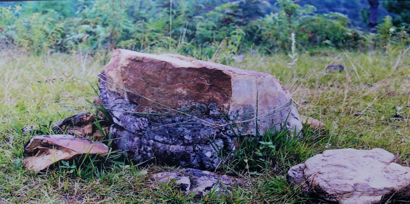
In the year 1829, as the war with the Company continued, David Scott got an intelligence report that enabled him to successfully devise a plan to capture Luk Sing Syiem. Scott’s men were more barbaric in their acts than they accused the people of Wahlong of being. The war ended with the beheading of Luk Sing and as a mark of insult, his head was taken and presented before David Scott.[12] Using oral narratives gathered from the Elders of Wahlong, a familiar story accounted for the betrayal of Luk Sing. A native of Wahlong had apparently been promised “shi rynniang ki tyngka”[13] or money stacked to one’s height. The narratives further pointed out that in 1830, soldiers of Iskat Saheb (David Scott) smashed Luk Sing’s head on Ki Maw Lympat Khlieh (Boulders) which are still preserved by the locals today. As children visiting Wahlong, we were always warned to never step on or touch those boulders for reasons unknown. In this instance, both the archival sources and oral tradition point out to the fact that Luk Sing Syiem was defeated and left headless as the war against the Company subsided. According to the local tradition captured in a documentary film on Luk Sing Syiem, the representatives/elders of Wahlong stated that David Scott was buried in the exact place where the head of Luk Sing Syiem was buried.[14]

Ki Maw Lympat Khlieh (Boulders) a place where Luk Sing Syiem, the last Chief of Wahlong breathed his last. Photo Credit: The Ever Living Museum, Shillong
This defeat signified the surrender of Wahlong which resulted in the ‘demarcation forged in blood’ as Wahlong was disintegrated and placed under the charge of a Sordar[15] (Sirdar) under the jurisdiction of three consecutive generations of rulers namely Dewan Singh, Suba Singh and Ram Singh of Hima Sohra. As mentioned earlier, Wahlong shared its borders with Sylhet to its south, hence the disintegration of the Hima paved the way for restructuring of the northern boundary of Sylhet according to the colonial interpretations to reap the maximum benefits from tax collected from Sylhet. On the other hand, it further shaped the understanding of a colonial hill-plain divide reflected in the idea that indigenous communities only belonged to the hills and foothills, embedded in the policies of the English East India Company. In a similar case, when the uprising of Tirot Singh which began in 1829 was subdued, the vast territories of Hima Khatsaw Phra were disintegrated according to the Company’s interest and the erstwhile Khatsaw Phra was renamed to Hima Nongkhlaw. Another instance can be observed in 1835, when the King of Jaintiapur was given a pension to surrender his plains territories in Jaintiapur located in Sylhet. These events even though rooted in the past certainly contain some imprints in the discussions and drafting of the Boundary Commission in 1947 which was tragic to the people of the southern foothills.
During the election of the fourth ruler of Hima Sohra, U Hajon Manick was made the chief against his cousin Bor Singh, the rightful heir to the throne. However, the latter chose Christianity as his faith and declined the throne as he felt incapable of carrying out the customary duties of a chief that involved participation in traditions and ritual practices of the pre-Christian faith. In the process, Bor Singh lost the title and property rights and was driven to a state of semi-poverty.[16] It was during the rule of Hajon Manick that Wahlong was reflected in a letter stating the region had significantly improved its trade in lime, oranges and other commodities; and the people had become peaceful.[17] Bor Singh’s son, Dr. Kormuni Singh Diengdoh[18] became a famous physician who served the people in the foothills. He is remembered as being fearless and dedicated to his service, carrying with him a golf club for protection against bandits. During his time in Lower Wahlong, Dr. Kormuni as an obstetrician assisted in my grandmother’s birth. Interestingly, as fate would have it, my grandmother married Stap Singh Kynta, one of the grandsons of Dr. Kormuni. As a gesture of gratitude and mark of respect towards Bor Singh and his sacrifices in giving away the throne and his family’s services in the welfare and mission activities in the War areas, my grandparents named my father Arbor Singh (Ar meaning second or II) after Bor Singh. Then, I inherited the name Sashi Teibor, (Sashi-sien in the Khasi dialect for Once again, Tei is to revive and Bor signifies Bor Singh).
As the title of the paper suggests, the ‘demarcations forged in tears’ refers to the Partition of 1947 and the hardships that came upon the people in the southern foothills of the War areas. Studies of Partition and its impact on the Indian subcontinent have for long taken shape around the regions of Punjab and Bengal. In recent decades however, studies on the North-East region have begun to emerge. If we turn back to the 1930s and 40s, the restlessness of communal politics was growing, especially with the commencement of the Second World War. The demand for Independence grew louder and became more concrete. As months of speculations over the liberation of India were discussed, the Muslim League’s pressure for a separate Muslim country under the leadership of M. A. Jinnah became a reality and thus the Partition became inevitable. The last viceroy of India, Lord Mountbatten was left with little option but to announce the Mountbatten plan or the 3rd June plan in 1947. Two of the provisions were that the fate of Sylhet would be decided by a referendum and secondly, the official task of dividing the subcontinent would be headed by a Boundary Commission. Subsequently, the results of the Sylhet Referendum in July 1947, tallied to 2,39,619 in favor of siding with East Bengal while 1,84,041 voted to remain in India. Therefore, as Sylhet became part of East Pakistan the task of demarcating Sylhet from the Khasi-Jaintia hills now lay with the chairman of the Boundary Commission, Sir Cyril Radcliffe and his Commission which comprised of four members – two from the Congress and the remaining two from the Muslim League. Eventually, the members of the Boundary Commission were not able to reach any satisfactory agreement.[19] Therefore, it was unanimously agreed that the final decision rested upon the chairman and accordingly the Award was made ready on the 13th of August 1947. As the Viceroy, Mountbatten had to bear witness and inaugurate the new dominion of Pakistan on the 14th and the dominion of India on the 15th of August respectively. Amidst the brewing communal tensions, killings, and insecurities the Award of the Boundary Commission was finally revealed on the 17th of August 1947.[20]

This bible is a parting gift by a Welsh missionary to “Kpa I San” or The Father of San (Sancimerly War is my paternal grandmother) on the 15th of August, 1947. Photo Credit: Sashi Teibor Laloo
Wahlong and the territories of Sohra, Malai Sohmat, Bhowal, Maharam, Langrin, Nongstoin, and Sohbar, Mawlong, Mawdon, Dwara Nongtyrnem and Shella which shared lands with Sylhet were abruptly cut off from their centuries old socio-cultural and economic ties with a stroke on a map through the Radcliffe Line. As the Khasi-Jaintia Hills were still a part of undivided Assam, it was estimated that Assam lost a total of 4769 square miles of territory and a population of 28, 25,282 (twenty eight lakhs, twenty five thousand, two hundred and eighty two) as a consequence of the Radcliffe Line.[21] It was particularly devastating for the Khasi-Jaintia and other indigenous communities of the North-East who had established their “paan” (betel leaf) cultivations in the plains of Sylhet.[22] Many chose to stay back and there is a thriving Khasi community in Bangladesh today.
My Meikha (paternal grandmother) Sancimerly War was 17 years old when she witnessed the Partition and the hardships met by the people. “The Partition robbed the War regions of their riches,” she said with a sigh. She recollected hearing rumors about the land being divided,[23] but she just like the others could not possibly fathom how. On the 17th of August, the Radcliffe Line was revealed and little did the people know that their lives were going to change forever. Gone were the expectations of a good sale of commodities, as East Pakistan, their only channel of export, now imposed an economic blockade. As rice (which was the staple food) and other basic commodities like salt, fish, oil etc., were solely sourced from Sylhet, life in the village became utterly chaotic. As the winter months set in, the orange orchards were in full bloom and the fruits had nowhere to be sold.

A telegram of distress from the Sordar (Sirdar) of Wahlong also known as Byrong, dated the 3rd of November, 1949. Photo Credit: The Assam State Archives
In a heart-wrenching letter to the premier of Assam by the Secretary of the Ri War Growers Association, Mr. Khylleb wrote that:
“On the 2nd November 1949, all Oranges, Pan Leaves and other perishable goods which were brought at Byrong Bazaar remained unsold. Now all the Bazaars were boycotted by the Pakistan people who are the sole purchasers of our goods. The Pakistan government made their own Bazaars opposite our Bazaars. Our goods remained unsold. It seems to me if this condition will remain; the people will be at stake and surely will die of starvation. I request and press your Honorable, as the oranges season is coming and if the people cannot sell them and their other produce, it seems to me the time has come that somebody will mislead them.”[24]
Conclusion
The southern Khasi-Jaintia foothills were the wealthiest regions with their abundance of minerals like limestone, coal, and agricultural produce like oranges, potatoes, areca nuts and betel leaves. However, the Partition of 1947 plagued the region with poverty. Just like my grandmother’s family who lost parts of their ancestral land in the creation of East Pakistan, they gradually migrated to Shillong by selling off their family’s jewellery as did the people who wandered seeking livelihoods into other parts of undivided Assam. The story and experiences of people whose lands where the Radcliffe Line has been drawn should be given equal weightage. It is certainly without a doubt that Punjab and Bengal faced the most atrocities as the hardships took a communal turn, however, the regions in the North-East were devastated economically as well as socially in the displacements and internal migrations.
The communities in the southern Khasi-Jaintia foothills had flourished immensely through trade and commerce. The region attracted traders ranging from the indigenous people, the Bengalis, the Mughals and European merchants transforming the Haats of Sylhet into a melting pot of diverse cultures. It is also very important to observe the major changes that had emerged on the advent of the west and their policies of mercantile interests. As the community celebrates and remembers the lives of Tirot Singh and Kiang Nangbah, the valor of Luk Sing Syiem and the people of Sohbar who challenged the power of colonialism also need a place in the region’s larger historical narratives. It is also necessary to address the erosion of history especially when colonialism observes situations or events from their perspective or their preconceived knowledge from the plains. The renaming of places and villages for their administrative purposes resembles a fresh layering of colonial concrete over a lot of local historical significance. Local history of events is further manipulated when the art of writing in the process of administration concretizes the baptism of all these places. This is where oral traditions still play a key role in understanding and formulating the history of indigenous communities. For centuries, the economy and basic necessities of the people in southern foothills have largely been derived from Sylhet. Therefore, with the results of the Sylhet Referendum, the Partition and dreadful economic blockade by East Pakistan in 1947, the people were at a grave loss. The people residing on the border regions have endured hardships of losing lands to East Pakistan as well as adapting to new methods of channeling their economy and livelihood. To make matters worse during the Bangladesh Liberation War, certain corridors of the Khasi-Jaintia foothills opened up to the refugee movements to assist the people in need.
With the able leadership of many great politicians whose followers and supporters were like wind beneath their wings, Meghalaya attained its statehood on January 21st 1972. I am often reminded that when negative news pertaining to the hardships in the borders regions with Assam or Bangladesh hit the front-page headlines, was that “Ki nong ialam jong ngi ha ki por ioh Statehood ki bun kam ha ka jing ia knieh suki te” which translates to “when Meghalaya achieved its Statehood the representatives were so much engrossed in the self allocations of government portfolios and departments that a blind eye was turned to the border regions.” It certainly does make a point. But in retrospect, when the leaders fought and achieved a bloodless victory of statehood, they were compelled to carry out duties at the same time to represent the aspirations of the people. My concern is to put forth a question to the representatives of the border regions who took the baton from the leaders of 1972 as well as to the ruling parties and the members of Parliament. It is 2020 and the people in the border regions still lack proper boundary demarcations, proper road facilities, and social infrastructure and security. If issues are continually being swept under the rug (and dusted once in 5 years) situations of encroachment and illegal settlement are definitely going to take a toll on the people and the region with time.
Notes and References
- Dutta, Binayak, ‘Recovering Sylhet’ in Himal South Asian, November 22, 2012, https://www.himalmag.com/recovering-sylhet/, Accessed on 1st July 2020. ↑
- Soso Tham is a revered Khasi writer and poet. The lines above translate to “Knowledge/Wisdom of the world we constantly seek, while that of our own we seldom know, how were our forefathers and their traditions of rule and governance.” ↑
- War, Kyntiewbor, in ‘U Luk Sing Syiem’ in The Silver Jubilee Celebration of the Sunjuk War Wahlong, Shillong, 2016, p. 10. ↑
- Under the Diwani Rights, the East India Company was entitled to the tax collected from Bengal which comprised today’s Bengal, Odisha, Bihar and Bangladesh. ↑
- David R Syiemlieh, Control of the Foothills: Khasi-Jaintia Trade and Markets in the Late Eighteen Century in Fazal Ahmed Qadri (ed.), Society and Economy in North-East India, Volume 2, Regency Publications, New Delhi, 2006, p. 333. ↑
- Considering there were many rulers of Hima Wahlong, the only influential personality that is remembered thus far is Luk Singh Syiem. ↑
- Letter of U Sirdar of Wahlongpunjee, Revenue Department, Assam State Archives. ↑
- Letter of Captain T.J. William, Public Work Department, Assam State Archives. ↑
- Kyntiewbor War, ‘U Luk Sing Syiem’ in a booklet commemorating the Silver Jubilee Celebration of the Sunjuk War Wahlong, 2016, p. 10. ↑
- Foreign Department, Letter No. 302, National Archives of India. ↑
- Ibid. ↑
- Ibid. ↑
- Kyntiewbor War, ‘U Luk Sing Syiem’ in the souvenir of The Silver Jubilee Celebration of the Sunjuk War Wahlong, Shillong, 2016, p. 11. ↑
- Na Dymmiew Channel, U Luk Sing Syiem (Freedom Fighter of Hima Wahlong) Documentary Film. https://www.youtube.com/watch?v=mr04Ol9Mu9g, Accessed on 11.8.2020.↑
- A local Administrative Head. ↑
- O. L. Snaitang, Christianity and Social Change in Northeast India, Firma KLM Private Limited, Calcutta, 1993, p. 162. ↑
- Foreign Department, Letter No. 302, National Archives of India. ↑
- I am indebted to my Aunt, Huldalin M. Kynta for her effort in keeping records of the family history in writing. ↑
- Gilbert Shullai, Assam Before & After the Inauguration of the Constitution of India in Bimal J Dev and Anil K Paul (eds.) Social Research, Volume 2 No 4, Institute of Social Research, Shillong, 1982, p.31. ↑
- V. P. Menon, The Transfer of Power in India, Orient Longmans, Bombay, Calcutta, Delhi, Madras, 1957, p. 418. ↑
- Binayak Dutta, ‘The Past as Present: Partition in Assam Politics during Independence and Beyond’, in Dialogue, Vol. 16, No. 1, Astha Bharati, New Delhi, 2014, p. 164. ↑
- S. N. H. Rizvi (ed.), The East Pakistan District Gazetteers: Sylhet, Dacca, East Pakistan Government Press, 1970, p. 104. ↑
- Sashi Teibor Laloo, ‘My Grandmother’s Tales of the Partition, 1947’, in Café Dissensus, 44th Issue, New York, 2018. ↑
- Home Confidential, Assam Secretariat, 1949, Assam State Archives. ↑
Sashi Teibor Laloo is a Research Scholar at the Department of History, North-Eastern Hill University, Shillong. The topic of his research is “Drawing Borders and the Making of Khasi-Jaintia Identity (1772-1972)” concerning the Southern Foothills of Meghalaya. He completed his B. A. in History Honors at St. Stephens College and received his Masters Degree from the University of Delhi. His interest revolves around the history and culture of the indigenous communities of Meghalaya ranging from their folklore, musical instruments, weapons, colonial accounts in the National as well as the State Archives and the old photographs that captured their past. Sashi has been a research assistant in a number of documentation of the region. He has also presented his research papers like the impact of the Partition of 1947 on the Khasi-Jaintia community, Orientalism, History of the Potato in the Khasi Hills et al. in various national and international seminars/conferences held in the country.